
Cold Springs Gold Project
Overview
The Cold Springs property is located in the western Great Basin of Nevada and covers high-grade volcanic-hosted epithermal gold-silver mineralization. It lies approximately 80km east of Fallon and is accessible by road. It covers an approximately 800 metre by 350 metre hill-top exposure of altered and silicified rhyodacite breccia which hosts a series of northwest-striking, sub-parallel gold and silver-bearing quartz veins. The property consists of 22 Federal Lode Claims centered on a small hill located along the up-thrown east side of NNW-striking range front normal-fault system.
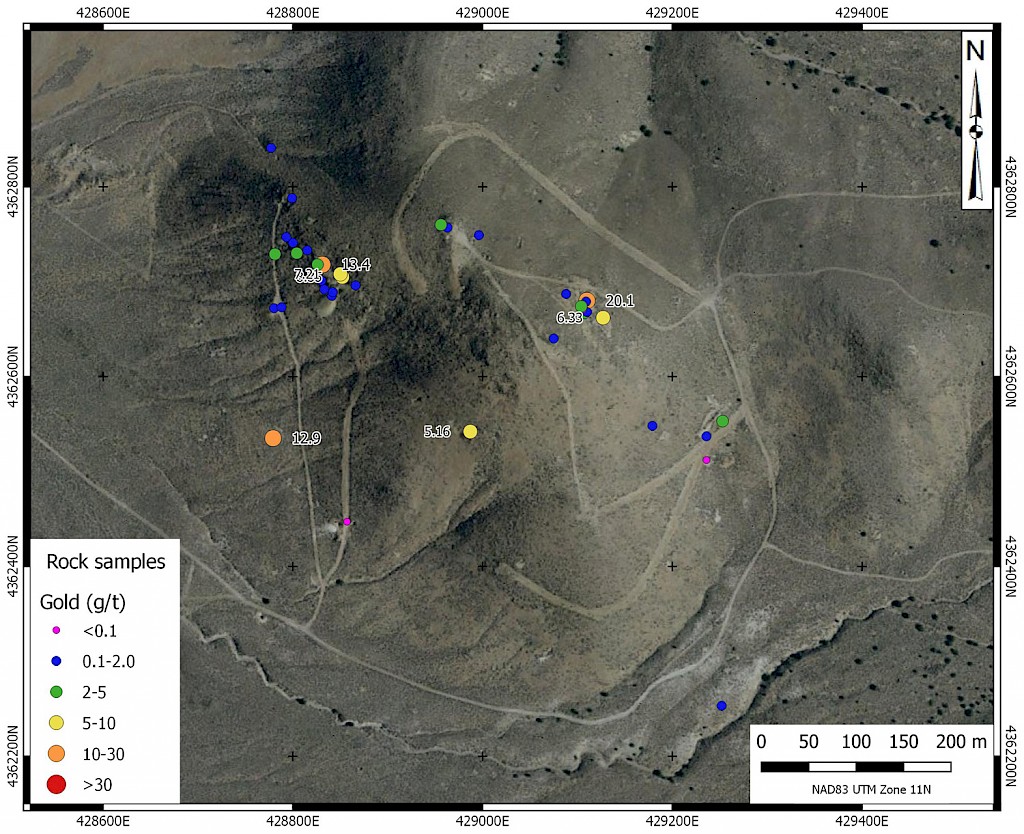
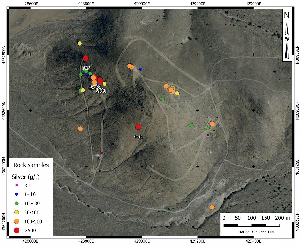
Previous sampling by Silver Range and others has yielded values of up to 64.9 g/t gold and 1,770 g/t silver from vein material. Limited reverse circulation drilling on the property has not adequately tested the mineralized system.
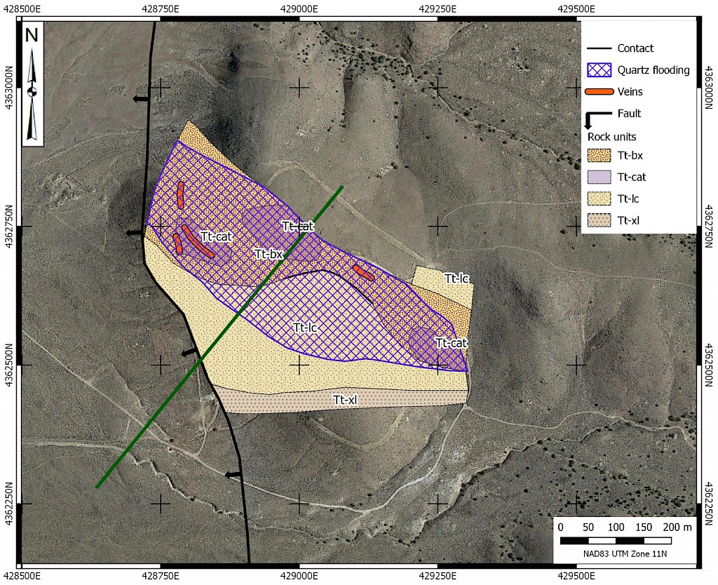
Four large, low-sulphidation epithermal veins are exposed in a wider 500 metre by 200 metre area of silicification. Gold-silver mineralized quartz-vein systems are up to 70 metres long and 2 metres thick. Existing data suggests the exposed mineralization is on the eastern-periphery of a larger hydrothermal system. Prior geological mapping and drill results indicate that the host volcanic tuffs, large silicified breccia-bodies and high-grade quartz veins dip west towards the Cold Springs valley. Additional segments of the gold-silver mineralization exposed on the hill-top, and potential hydrothermal feeder conduits (faults) may have been down-dropped to the west across the range-front fault system and are now hidden beneath valley-fill alluvial cover.
Combined CSAMT and IP geophysical surveys have identified a large resistivity low located beneath alluvial cover to the west of the range front fault system. The resistivity low is interpreted to be argillic alteration surrounding the core of the hydrothermal system and/or sulfide-bearing quartz feeder veins.
Project Photos

LOCATION & ACCESS
The Cold Springs property is located at 39°25’ N, 117°50' W in Churchill County, Nevada. It is 66 km west-southwest of Austin and 80 km east of Fallon, the nearest supply centre. The property can be accessed by 2WD vehicle via a 1.4 km dirt road from Cold Springs Station on U.S. Route 50. The property consists of 19 Federal Lode Claims centred on a small hill along the range front.
EXPLORATION HISTORY
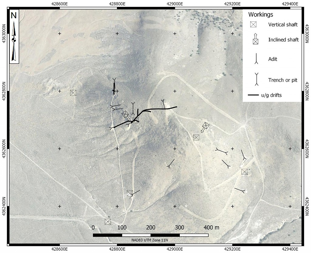
A letter dating from 1935 states that Cold Springs was discovered in the 1860’s. By the early 1930’s development on the current property consisted of 3 adits and 3 shafts as well as numerous trenches. Small production was also reported. In 1950, G. Peer restaked the property as the Oroplata Claims and reportedly drove 610 m of adits and drifts, excavated 122 m of shafts, and performed surface stripping with a bulldozer. In 1979, Phelps Dodge Corp. staked the Gate claims around the Oroplata claims, and completed 8 drill holes in 1981. In 1982, ASARCO Inc. restaked the Gate claims and possibly acquired an interest in the Oroplata claims. They drilled 8 holes but walked away. The WX Syndicate optioned the property and drilled 26 mostly shallow holes on property during 1987-1988. Highlights from all of this work included 3 m @ 0.808 g/t Au; 3m @ 3.86 g/t Au; and 18 m @ 0.62 g/t Au. Northern Abitibi Mining optioned the property in 2006 and conducted mapping, CSAMT and drilling (5 RC holes / 1664 m). Their targets were deep, steeply dipping conductors underneath the mineralization on the hill. While surface sampling returned up to 69.4 g/t Au and 1280 g/t Ag drill results returned low grades (30.5m @ 0.4 g/t Au / 22.9 g/t Ag including 3.1 m @ 2.2 g/t Au and 98.3 g/t Ag). The property lapsed and was restaked by Silver Range Resources in 2016 who conducted geological mapping, sampling, 3D induced polarization & resistivity surveys after purchasing and compiling all available drill data from the property.
GEOLOGY & ECONOMIC MINERALIZATION
The Cold Springs Property is underlain by mid-Tertiary rhyodacite breccia and is situated on the NW rim of a volcanic centre associated with the Oligocene Ignimbrite event. Numerous gold and silver occurrences occur in the NW quadrant of the interpreted caldera complex. At Cold Springs, gently west to southwest dipping gold and silver bearing quartz-chalcedony veins up to 70 m long and 2 m thick cut a larger zone of silicified tuff-breccia. The silicified breccia carries > 0.1 g/t Au and > 2 g/t Ag near the top of the hill while higher grades are confined to the larger crosscutting veins. Historic grab sampling of these veins returned assays up to 64.9 g/t Au and 1,280 g/t Ag while initial sampling by Silver Range in 2016 returned grab samples up to 20.1 g/t Au and 1,770 g/t Ag from similar material. Geological mapping and drill results indicate that the host tuffs, the large silicified breccia and the high grade veins dip towards the Cold Springs valley and are down-dropped beneath alluvium across a range front fault. The mineralization exposed on the hill at Cold Springs appears to be merely the eastern periphery of a larger epithermal system. Geophysical surveys have identified a large resistivity low west of the range front fault and the exposed mineralization in basement rocks beneath alluvium. This is interpreted to be argillic alteration surrounding the core of the hydrothermal system.